Central Meteorological Observatory: From September 26 to 28, the super typhoon "Olu" will seriously affect the South China Sea and the coastal areas of South China.
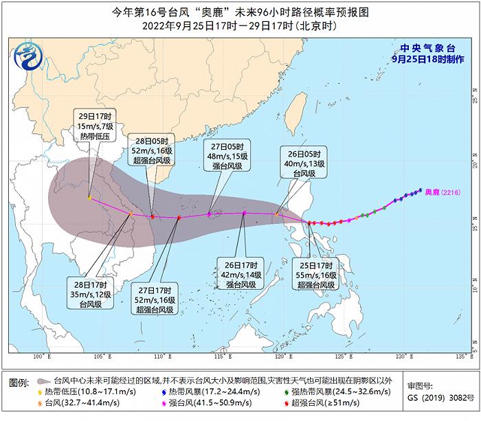
According to the website of the Central Meteorological Observatory on September 25th, Typhoon Olu, the 16th this year, was formed in the east of the Philippines on the afternoon of September 23rd, and rapidly strengthened from a strong tropical storm to a super typhoon from the evening of the 24th to the night. At 17: 00 on the 25th, its center (super typhoon level) was located on the northwest Pacific Ocean about 135km north-east of Manila, Philippines, and the maximum wind force near the center was 16 (55m/s).
It is estimated that Olu will move to the north-north direction at a speed of about 25 kilometers per hour. It will land on the eastern coast of Luzon Island in the Philippines this evening (48-55 meters/second, with a magnitude of 15-16, strong typhoon or super typhoon), and it will pass through Luzon Island at night, with a weakened intensity. It will enter the central and eastern South China Sea from the morning of 26th, then move to the west, and gradually approach the eastern coast of Vietnam. The Central Meteorological Observatory issued a typhoon blue warning on the morning of September 25th.
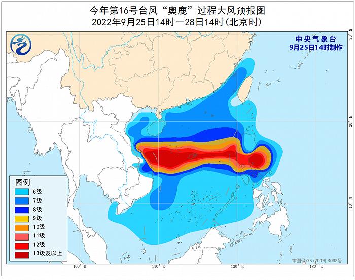
Gale forecast: Affected by cold air and Olu, there will be 6-8 gale in the western coast of Taiwan Province Island, Fujian coast, Guangdong coast, Hainan island coast, Taiwan Province Strait, bashi channel, most of the South China Sea, Beibu Gulf, Qiongzhou Strait and Sansha Islands from the night of 25th to 14: 00 on 28th, with gusts of 9-10, among which the winds in the central South China Sea, Xisha Islands and the waters near zhongsha islands.
Rainfall forecast: From 26th to 28th, there will be heavy rain in Hainan Island and Sansha Islands, and local heavy rain; The accumulated precipitation in the above areas can reach 80 ~ 120 mm, and the local area is more than 200 mm; The maximum hourly rainfall is 30 ~ 50 mm.
Meteorological disaster risk forecast: From 26th to 28th, flash floods and geological disasters occurred in eastern Hainan Island, and some small and medium-sized rivers had meteorological risks close to the warning water level.
Typhoon Olu has a fast moving speed and strong intensity. When it affects the South China Sea and South China coast, the strongest typhoon level or super typhoon level can be reached, and the wind is strong. Ships and personnel sailing in the central South China Sea, Xisha Islands and waters near zhongsha islands need to be evacuated in time, and ships near the South China coast need to return to Hong Kong in time to take shelter from the wind.
In addition, there has been continuous rainfall in Hainan Island since September 20, especially in the eastern part of Hainan Island. Due to the superposition of typhoon heavy rainfall, the risk of mountain torrents, geological disasters and floods in small and medium-sized rivers is high, so it is necessary to strengthen prevention, and low-lying farmland should be dredged in advance to prevent waterlogging disasters.